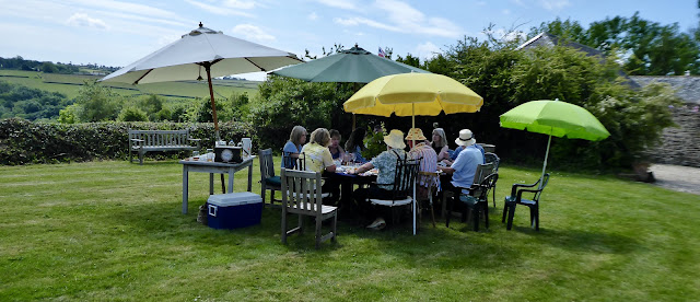
But that is not what this post is about.
You see, as the weekend approached, my mind kept swinging back (unbidden) to reflect on a trek I once did into the Ben Alder Forest, up there in Scotland. So I eventually looked out my trusty log of those far back days and looked it up. 1982. Really? As long ago as that? May-June, a two week trip from Oxford on my Moto-Guzzi… And then it dawned on me: the day I reached the summit cairn/trig station of Ben Alder was forty years ago – to the day, this day, Friday 'party day' – as far as I can compute…
In the twenty years of my 'Scottish Period' that excursion had been one of the very best. I bagged eighteen Munros, I had startlingly good weather, the experiences rose to a crescendo and included some very distinctive wild life, I had solitude but not loneliness, I ate well, slept well; I read a compelling new book called Midnight's Children. I was FIT damn it! And it all went swimmingly, very well.
I have now poured over the mapping to see where I went, and at what points I pitched my shelter. The pictures I took have not stood the test of time particularly well: there are the tell-tale spider tracks of the mould that seems to eat colour transparencies even when stored with care. Oh for a digital camera then!
So Here Goes. Just for me, but if you are interested, you might pass a few minutes sharing this recollection with myself, if you are a hill lover, past and/or present. I'll try to be brief and try to stick to the point.
Drove from Oxford to Derbyshire, overnighting at my younger brother's home, then on again to a second night at a friend's home at Great Ayton, and from there up into the Scottish Highlands south of Crianlarich – which was my sort-of base for this two weeker. I camped on arrival in Glen Falloch and turned my attention to the Munros thereabouts. I devoted my first three days in the area to ascending Ben More, Stob Binnein [day one, a Sunday], Cruach Ardrain, Beinn Tulaichean [day two, Monday], Ben Lui, Beinn Oss, Beinn Dubhchraig [day three Tuesday].
And of these, the finest was Ben Lui and its associated summits.
After that (centred on those four nights camped close to the West Highland railway line) I took myself to Crianlarich Youth Hostel for the Wednesday night which is where I left the bike for the main event: my trek into the Ben Alder and Ardverekie Forests! Here we go!
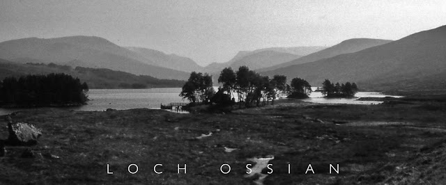
By train from the conveniently hostel-adjacent Crianlarich station, north to the remote Corrour railway halt, without connection to the road network. I walked the Loch Ossian track, past the hostel and through the trees fringing the loch's southern shore, loud with cuckoos, sheltering me from the increasing heat of the day, passing by a pair of red throated divers cavorting on the loch, passing by Corrour Lodge, over the bridge and onwards up the Uisge Labhair (that's a river) to a site where I could put up my humble tent, grid reference NN474729. A hard back-packing day in almost cloudless heat, but to a spot that I recall as being very lovely, comfortable, discreet, where two major streams meet and 'loud with the music of water'. An early evening thunderstorm did not dispirit your author. I slept well there for three nights.
Saturday was also bright and clear so I picked off the first of the two Geall Charns in the area, this being the larger, higher of the two at 1132 meters. It has a huge almost flat plateau summit with several summit like bumps, one of which is the summit of those summits. Up here? Golden Plover nesting all over that space, wonderful to see, hear and be amongst. And hundreds of deer once again using the retreating snowfields of the adjacent choires or corries to cool themselves.
Sunday, and time to move on. I packed up and went up and over the Bealach Dubh in cloud, noting the aircraft wreckage scattered thereabouts (not recent). Signs of man. After the initial publication of this turgid travelogue, the son-and-heir, ever mindful of his father's inaccuracies and keen to check on the authenticity of reporting, kindly forwarded a link, enlarging on what happened here back in WW2. I am grateful to him for this intelligence. And then I walked all the way to Loch Pattack. Why? My log records it was a pretty barren stretch of terrain even when on the faint path made by other misguided types perhaps. You ought to see it on the map I carried. What was I thinking of? Anyway then I turned back west up a valley called An Lairig and even now I can recall it as a featureless barren place. An unaccompanied white boxer dog briefly appeared from the tussocks, spared me but a glance and continued about its business… I eventually camped at about 730m well off the beaten track, because you see, I had a plan. Hmm. Grid reference NN489783. Don't go there. You won't like it. I spent two nights. Good views of Loch Pattack, mind.
Thankfully Monday was a sunny day but with quite a lot of relief cloud about. Yes, I was here to mop up some Munros I'd not be likely to get to again and with some mild scrambling on offer. Once more I won't trouble you with the route I took, or rather made as footpaths there are not, around these parts; the map is over-optimistic. First then to the summit of the closest Munro, Beinn a'Chlachair [1087m] largely a cloud swathed experience of ankle twisting boulder fields and no views either down into the mountain's deep northern Coire (Corry if you prefer). Not to worry, I started back off the hill almost the way I came at first but then veered more and more northwards as the sun finally got through and I gained a stalker's path, lots more golden plover hereabouts too, and up the smashing little Creag Pitridh [924m] where the views were epic! You see, you do have to take the rough with the smooth, it was worth the grind. Well I think so… from this remove… I lunched up there and really did marvel at the mountain views all round, some partly masked by clouds, but still grand for all that, the Ben and Grey Corries etc.
One more to complete the set: Geal Chàrn [1049m, number two]. A bit of a tedious summit if memory serves, but sporting a trig station as does Alder of course, or did when I turned up there. I returned to my tent via various humps and dried up bogs to be entertained by some low flying fellows of the RAF. Glad when they had gone. Lots of pippets nests, I noted.
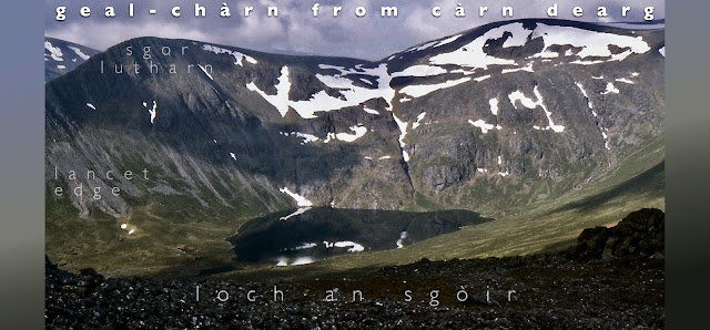
Tuesday. Another scorcher. I packed up early and started back west. But with a final Munro to take in: Carn Dearg [1034m]. I parked my pack off the An Lairig path by this waterfall (left) and zipped up (hah) and traversed to the summit cairn of CD, where I disturbed a hare seemingly fast asleep thereat. Great views again, as you'd expect by now: A stonking view of the higher Geal-Charn, (see herewith). Dashed warm too.
After two hours I had got my pack back on my back and heading past a wee loch noted it to be full of perspiring red deer, then on to pathless hags and troughs and forest tree stumps, to eventually reach (below left) Loch Ghuilbinn, honestly, I kid you not, I had a brew up on its beach fgs!
I could not find a suitable camp spot with water: the stream beds were dry hereabouts. Neither are very distinguished hills, so . . . I got some much needed water from the Ossian hostel, tramped on to arrive at the station, boarded a train south back to Crianlarich, the hostel and a night in a bed. I still had enough vim to oggle the Blackmount from the train and mull over plans for a 1983 trip to them…
No rest though. Oh no. Wednesday I was back on the bike to drive down to Loch Awe. But this account stops hereabouts. Yes, I bagged both Stob Diamh [998m] and Ben Cruachan [1126m] to add to my Munro score, even did the principle ridge in the process and had my sylph like countenance snapped by a fellow summiteer on the top thereof but, well, its a bit of a honey pot summit, isn't it, and camping near it is a bit of an ask, and there aren't any related Munros to draw one to the area, etc. so there we are, done that, was rather my attitude I'm afraid as I removed the rude notice some job's-worth left on my Guzzi bike seat where I had parked it in the damned car park for the power station under the mountain. A seven hour round, I was pleased enough at the time, but well, you know, a sort of transient satisfaction.
I drove back to the hostel, overnighted there and the next day, took off back to Oxford, via Great Ayton. Had some jolly storms on the way from there to Oxford but my spirits could not be dampened: for once I had a fully waterproof suit to bike south in…
The trip did for my walking boots by the way.
In 1983 I was back up there again, based again at Crianlarich, and riding the Moto-Guzzi again. I did the Upper Glen Lyon Munros (some anyway, like those indicated above Bridge of Orchy in the railway snap) and much of the Blackmount, together with the three Munroes I missed above Glen Falloch, just to be tidy this time: another seventeen hills to add in. Don't worry, I'm not going to roll that one out here … just now. A long time ago now (>sigh<).
Just one other note: I used the now long discontinued OS 1:25000 10x20 km maps second series for this and many other Scottish jollies. Proper maps. Easy to handle in the field. Not those more recent bloody daft Outdoor Leisure maps, the size of Rutland and a devil to open and close in even the slightest breeze… and sometimes double sided, fgs! I mean, how stupid is that? Where ever you are looking for, it is always au verso, of course it is. Progress I suppose. Explorer Maps? See above, just another level of Outdoor Leisure. The criticism holds good for them as well, don't get me started. Fine for your table top planning but up the hill? Mais Non!
Of course, most folk on the hills these days no doubt proceed with one hand extended, sporting a smart phone to tell them where they are, where they are going, how long it may take, who they are, and who wants to know. Very useful I'm sure, reassuring and all that, don't want folk wandering off and getting misplaced, now do we? But for me and many like me (there are still a few) the map remains supreme, while we can still get them in printed form that is. OS Maps used for the Ben Alder section were a bit of NN26/36 Corrour and mostly NN47/57 Mid Loch Ericht. No longer available in this most useful of formats. Look at the price!
To conclude. An excellent two weeks then, my rating. What I fail to convey in the above, is the pleasure of solitude one can gain by such an endeavour, which I have often sought, supported even to the extent of hiding from other walkers out in the wilds. Plus sleeping out in it: big Plus that. Plus eating one's carefully planned meals out there, coffee never tasted so good. Sight and sound. Light. The quality of the rock and lochan. Birds and beasts of the field. Time to think. Plus much more. Plus Plus plus…
If you have been, thanks for reading through this. Any the wiser? I've got the maps and m'log still if you want to relive it with me… no? Hmmm… Don't blame you, unless you've done it you won't get all this and that's a fact. Show us a dvd now, that would be the business, would it not?
This was an experiment. I don't think it worked. But it has prodded some of my Random Access Memory back into life albeit with some serious 'drop outs'. Forty years on. What can one expect?


