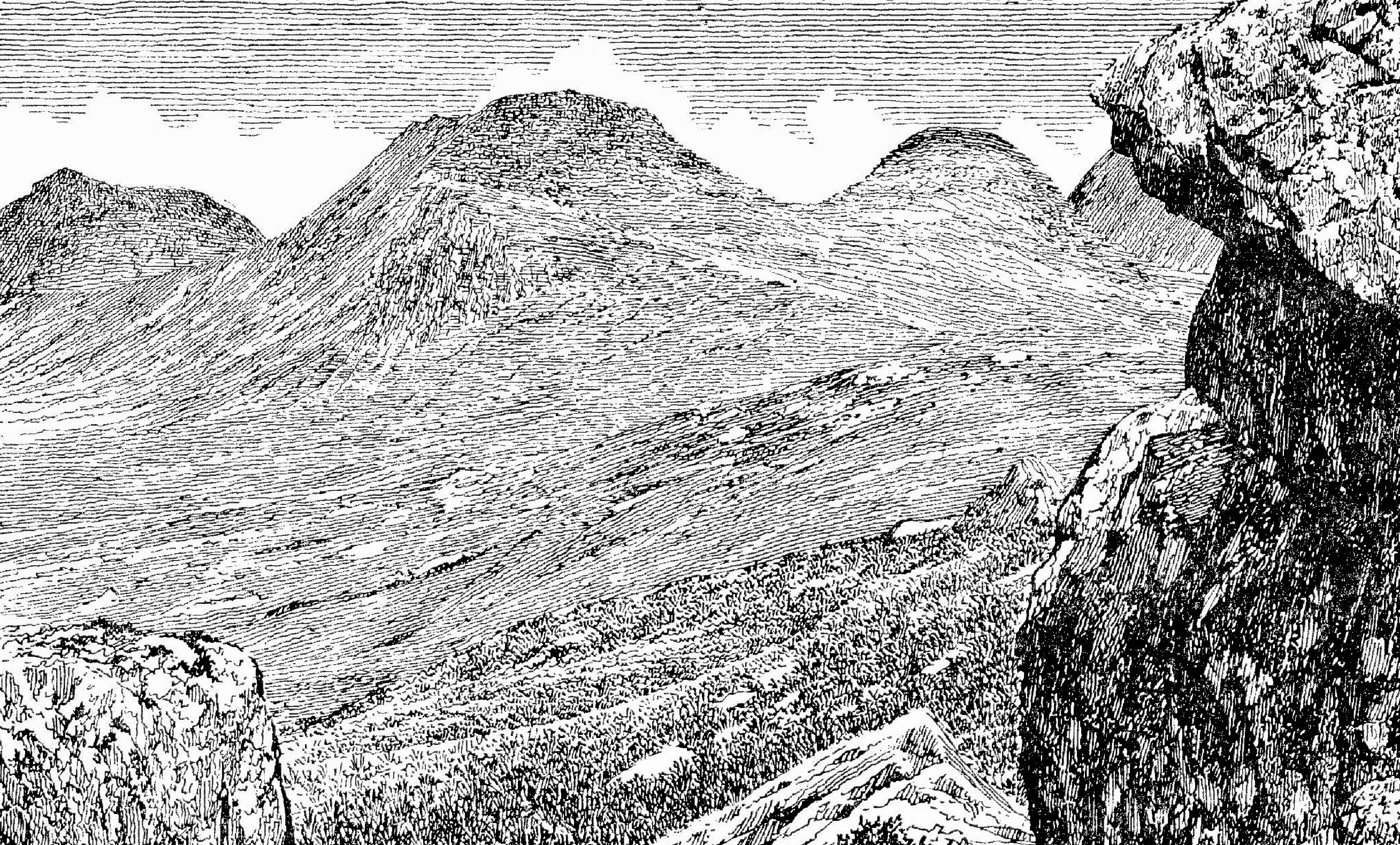
2023, THIS YEAR, MARKS AN ANNIVERSARY (it marks many – but this one is specifically mountainous) because dear reader, it is half a century, fifty years, (50) since I first became personally acquainted with the elegant, gaunt, challenging and majestic collection of tops, peaks and pinnacles of Torridonian Sandstone that is collectively known as An Teallach. 1973.
You’ve got to believe it, fifty years ago. What is more I walked to it’s southern flanks all the way from Loch Maree, right through the Fisherfield Forest (no trees), taking two days in the process. I wasn’t alone in this endeavour: ‘we’ consisted of a former matrimonial associate and someone’s dog, a Scottish Cairn Terrier that tailed us (well led the way, mostly) from Kinlochewe, seemingly with aspirations to ascend distant An Teallach. Maps were hard to come by at this time: I was reduced to projecting this escapade on the one inch OS seventh series sheet (number 20, I’ve still got it!).
The weather was good. We’d come up by train to Glasgow (overnight I think) where we unloaded our wheels (an entirely inadequate Honda motorcycle) and then rode all the way to Achintraid youth hostel to overnight. Achintraid? Had a wonderful stay there in 1972 when we used the place as a base for walking the Applecross Hills… From there we rode across to Kinlochewe via the narrow-roads-with-passing-places that still prevailed in those days, to leave the bike in a convenient barn and backpack off up to Loch Maree and then north into the wilds, flanking Slioch (that’s the mountain that hangs over Loch Maree, earmarked for an ascent on our return leg back to Kinlochewe).
Wild country! Probably the largest slab of wilderness left in Scotland (well it was last time I walked in it, back in 1985). No habitations, no roads across, often pathless, and a long way, in any direction. But the weather good, even hot at times, that first day in the wilds: we backpacked to a divine spot to sleep out (camp) on the edge of flat calm Lochan Fada.
I’m not going to bang on here about the pleasures and challenges we experienced crossing this land. It was a very fair traverse, the dog added interest at times; the landscape was beautiful, remote, unpeopled (save one lone walker). We found, and utilised vestiges of paths where practicable (stalker’s), lunched by a loch side (Nid: brewed coffee), arrived at the Strath na Sealga and camped by the broad shallows of the Sealga river surrounded by peaks of varying distinction but principally the flank of Sáil Lath, the southern terminus of the An Teallach complex. We paddled in the river, we ate well and fed the uninvited mutt as best we could.
At this time I was still not disposed to employ a camera (I hadn’t got one) relying on maps and memory to record the exploits. We travelled as light as practicable. My written record also is somewhat perfunctory, and even if I were to recite the route up over and around our target mountain it would most likely fail to mean much to anyone not familiar with the hill, wouldn’t it?
It was wonderful. We did the round of An Teallach in glorious weather. It is exposed and often testing of one’s head for heights. The views almost defy description – in clear weather – which it was, very much so; the circuit of the ridge challenging stamina and resolve. We rose to the it. Exhilarating; better still we met no one, had the hill to ourselves. After coming back down, we explored the deep Corrie (Toll an Lochan) and the forbidding loch imprisoned therein. There was snow down there, in shadowed drifts. The dog did it all – plus extras. I found a full bottle of paraffin, like a gift from heaven it seemed – we were running low on fuel for the primus. Yes! an experience, pleasure, fulfilment, and had ourselves a another night of great peace by the babbling waters of the Sealga river. I would return! And did: twice more; but sans the rest of the party, this one at least.
Our way back was the long way round. It seems that we managed the return smoothly over and through what is after all, very rough, lonely and impressive country. The weather turned less fair, even to the extent that as we crossed the long ridge to the second target mountain, namely Slioch, we had to abandon the ambition to visit its cloud wreathed summit, to camp instead in the forests bordering Loch Maree, where it was possible to dry our clothes under the conifers even as the rain sluiced down. Concorde (the aircraft, you may have heard of it) was making test flights up the west coast at the time, prior to entering service, so we got a number of sonic booms. The dog ignored them entirely. Cuckoos. Lots of them. They weren't fussed either.
Upon our approach to Kinlochewe our cannine spruced himself up, went on ahead – and disappeared into one of the houses thereat, with not so much as a nod of farewell or vote of thanks for victuals and shelter shared. Dogs…who needs them?
The remaining personnel retrieved their wheels and went on to visit Skye, camp in the remote Loch Courisk, climb in the Black Cuillin etc. etc. And other stuff. But the wild country between Lochs Maree and Broom became a favourite with me. Subsequently I have visited most of the Munros therein… Including that most remote, coveted and aesthetic of Munro mountains, A’Mhaighdean. That would be next time perhaps…
I am indebted to the late Alfred Wainwright for the illustrations used in this post. Yes, it's him, he's done illustrations of all the Munros, and some.
The opening illustration is of Coire Toll an Lochan, An Teallach; the second is of some of the hills of the Letterewe Forest; the illustration above is a view of Slioch from the west bank of Loch Maree. I took no pictures y'see. No camera in '73…
Here endeth part one, reflecting on what some call the Fisherfield Forest, others call the Letterewe Forest, the Dundonnell Forest… and so on. All correct in part. Essentially it is the wilderness extending from Loch Maree to Loch Broom or between Kinlochewe and Dundonnell. North west Scotland. South of Ullapool.
SIX YEARS ON – IN 1979, after investing in fresh tentage and other kit, after a number of other exploits on the wild side, I outlined a trip to what I then called the Dundonnell Forest – to two like-minded individuals. We could manage a fortnight only to coincide in the August-September period, when the mosquitos are at their very worst. It would do. I drew up the plan and it was met with general approval. This is, if you like, part two.
By now I had become more familiar via book learning with the distinguished Munro A’Mhaighean – claimed to be the most remote Munro of all and seemingly with some of the best vistas in all of Scotland from its summit. So it was my principle objective, but I added in the carrot of the much better known An Teallach as a suitable target. This is how it went:
DH and self drove (in the latter’s company car) from Oxford, stayed over with TA in Durham, the third companion, and eventually fetched up in Kinlochewe after arriving late into our chosen area of Scotland and a frightful camping experience near Achnasheen with the insecta. We each carried our own kit, food and tentage. But still no camera, not even one between the three of us. It wasn’t an issue then.
The weather was indifferent, muggy, cloudy but dry as we set off along the north-east bank of Loch Maree, all the way to Letterewe where we turned up the hill to toil through Bealach Mheinnidh and to cross the causeway between Dubh Loch and Fionn Loch where we camped. It was my proposal to stay here two nights and travel light south-east to climb A’Mhaighdean plus any other hills adjacent that took our fancy. However, as is often the case the night turned wet, the following day even wetter and we contented ourselves with enjoying the scenery, eating, drinking (coffee) and catching up on stuff. We did get a view late on in the day I think, something like this (below). That's A’Mhaighdean right of centre and Ruadh Stac Mor behind it.
So no A'Mhaighdean this time… another time may be…
Once again the party had exemplary weather on An Teallach, I enjoyed doing it again (we separated so that we could scramble round at our own pace; we saw no one else) – that, and the camping, right within the Coire an Toll Lochain, in the foreground of this Wainwright rendition, quite a spot, what? The hill tends to funnel strong gusting winds into the corrie, coming down over the pinnacles and suddenly battering one’s shelter in a rather alarming fashion. That was our experience at any rate. But worth that inconvenience at least for a couple of nights.
We found some aspects of the return trek rather hard work, daunting, even a touch tedious, unrelenting. It is (or was) quite empty and still; no fences, walls… and rather indistinct paths, if any. Few signs of human interferences apart from the absence of most trees.
En route back, we came across a considerable set of waterfalls south of the Loch Meallan an Fhùdair which simply did not feature on the maps I had access to, then or now. We discovered them in 1973. in an otherwise quite featureless, pathless part of the round – so it was quite reassuring to stumble upon them again, a second time. Sorry, no pictures, no camera you see, I might have mentioned that previously.
And no chance either to try for the Slioch summit (seen from near our final loch side beach very wet camp in the Wainwright illustration below) before returning to Kinlochewe… another time may be (again)? We shipped out down Gleann Bianasdail and bolted to Kinlochewe for some much needed R&R.
Here ends part two. The '73 contingent got a good day on Beinn Eighe in this trip and some excellent coastal camping, it wasn't all wet either… happy days!
ANOTHER SIX YEARS ON… and I have a camera. With film in it.
I was determined. The ambition burnt strongly. This time I'd get to A'Mhaighdean, see those views and record same for my own private posterity. Hmmm… read on… This is part three.
This time the party is once again three persons. Dr G, RS and my good self. In two cars! That's because I was going on to spend more time in the Highlands than my companions would, after the three adventures we planned to do together, i.e. Fisherfield, Beinn Dearg (Inverael) and Torridon… Here's Wainwright's take on the two Beinn Deargs of Letterewe, visible in my photo above:
I drove Oxford to Nottingham, overnighted with my companions then we left at 0400 in convoy, to get right up into Wester Ross by early afternoon. The weather was dirty upon arrival so we took ourselves off to Dundonnell hotel and had tea before returning down the road, parking and beginning the jaunt outlined above.
The photograph that introduces this third part of the Fisherfield and all that post was indeed taken by my good self with the last exposure in my camera, as the daylight drained away, after returning from the Beinn a' Chlaidheimh ascent. Time for a new film, obvs. I wound the exposed film back into its cassette, as you do, removed it from m'camera and stored it safely, ready to send off for development. Transparency film you see. In preparation for the big day (the visitation to A'Mhaighdean) I loaded a new, unexposed colour film into the Pentax… but what I didn't do, right? what I failed to do, was to ensure the new film was fully engaged with the wind on mechanism. It wasn't.
Even though the wind-on counter indicated each advance after making an exposure, back inside the camera, the film was not advancing, but just sitting there. It wasn't until the counter showed 38 (36 exposures on the film, so finished) and I could seemingly still advance the film, that my suspicions were aroused and I realised my awful error. Merde merde triple merde… the film was unexposed, had not advanced and I'd failed 36 times to capture a scene. God's Teeth!
The A'Mhaighdean round was excellent. I scored five Munros (six if you count Beinn a'Chlaidheimh) the last three/four solo. The views from the title mountain were as superb as I had been led to believe, exquisite in fact, as were other summit views, the terrain steep, sharp, very varied challenging. Probably one of my best single days out. I arrived back at our camp, exhilarated and reasonably confident that I had captured on film this most memorable of circuits, a classic of Scottish hill climbing. I slept well that night, the stars out, just the sound of the river, after saying good night… the error I had made with the SLR wouldn't come to my attention until we'd left this area, finished our exploration of that other Beinn Dearg and climbed the Horns of Alligin! That part of our jolly falls outside this account however.
So to conclude, here are a number of Wainwright's representations of this fabulous wilderness. They give some idea…
 |
This is Beinn a' Chlaidheimh, climbed on day two and now relegated to Corbett status as it is believed to be just a fraction less than 3000 feet in height. Shame! It was a Munro when I climbed it!
|
 |
Here is Mullach Coire Mhic Fhearchair as seen by Wainwright from Gleann na Muice
which drains Lochan Fada. Can't place it?
Where's the map?
|
 |
This is a surviving snap of distant Beinn Tarsuinn left centre, looking south up the valley we trekked up to get to A'Mhaighdean (whch is hidden to the right) y'see…
|
 |
And this is Beinn Tarsuinn from Wainwright's southern viewpoint – so that must be a distant A' Mhaighdean on the left (Tarsuinn is centre) because I climbed Tarsuinn after
A' Mhaighdean as I progressed east. Do you follow me?
Well, it gives you some idea at least, if you want it. I could have filched some snaps from books I suppose, but none I've found do the landscape justice, although some later visitors to these summits have clearly had better luck with their image making… go on line if you feel like it!
Acknowledgements again to the late Wainwright for his excellent drawings. Redolent! The few photos herewith are mine, and I end with an impression of Beinn Dearg Mhor from Shenavall drawn by ME. We should have climbed it even though it falls just short of Munro status. Next time eh? Yeah… right.
Sorry about the lack of maps. Credit for the sketch maps I have borrowed goes to Jim Renny (SMC).
Thanks for your time if you read through this… it was a piece of pure indulgence on my part, upon an anniversary that influenced my recreational outlook for many years thereafter… if this text has turned blue for you, I can't hazard a guess as to why that should be. Not my doing.
I'm past caring…
|